 New Caledonia – French territory
Geographical situation and geophysical context
New Caledonia is a French overseas territory located in the southwestern Pacific Ocean, east of Australia. It is part of the Melanesian archipelago and consists of the main island of Grande Terre, the Loyalty Islands, the Isle of Pines, and several smaller islands. Here are some key aspects of the geophysical context of New Caledonia:
- Tectonic Setting: New Caledonia lies within the Pacific Ring of Fire and is situated along the boundary between the Pacific Plate and the Australian Plate. It is located on the eastern margin of the Australian Plate, which is being subducted beneath the Pacific Plate. The subduction of the Australian Plate beneath the Pacific Plate has given rise to a complex tectonic setting in the region.
- Ultramafic Rocks: One of the distinctive geological features of New Caledonia is its extensive deposits of ultramafic rocks, particularly nickel-rich laterites. These ultramafic rocks have formed through the long-term weathering and alteration of ancient mantle rocks. New Caledonia is one of the world’s largest producers of nickel.
- Coral Reefs: New Caledonia is renowned for its rich and diverse coral reef ecosystems, which are considered among the most pristine in the world. The reefs support a wide variety of marine life and are protected as a UNESCO World Heritage site. They contribute to the geophysical context of the islands and provide essential ecological services.
- Mountainous Terrain: New Caledonia features a rugged and mountainous landscape. The main island of Grande Terre is characterized by mountain ranges, such as the Chaîne Centrale, which runs centrally through the island. These mountains are a result of tectonic forces and geological uplift.
- Lagoons: New Caledonia is surrounded by extensive lagoon systems, particularly along the western coast of Grande Terre. These lagoons are home to diverse marine habitats, including seagrass beds and mangrove forests, and are important for local communities and tourism.
- Seismic Activity: New Caledonia experiences occasional seismic activity due to its location within the tectonically active region. Earthquakes can occur as a result of the ongoing subduction and deformation of the Australian Plate beneath the Pacific Plate.
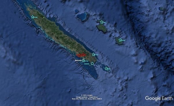
New Caledonia seismic network, FSDN code : NC
The New Caledonia seismic network is managed by the French Institute for Research & Development (IRD). This network, transmit data in real time to the data center in Noumea to help them monitor seismic activities occuring in their territory space. Below, is the list of permanent seismic station, with code officially registered into ORSNET:
- ONTNC (Ouen Toro), located in Noumea, less than a kilometer from IRD. The equipment is in a “historic” seismic vault built in 1958 during the International Geophysical Year.
- OUENC (Ouen Island). Located on Ouen Island, on the heights of the tribe, in an old OPT relay station rehabilitated for the occasion.
- PINNC (Pines Island), located on Pines Island, at the tribe of Kéré, on private land.
- YATNC (Yaté), located on the Mamié plateau, tribe of Unia.
- MARNC (Maré), located at the secondary school of La Roche, behind staff housing.
- LIFNC (now JNKNC) (Lifou), located on the Wanaham airport ground, in a large cellar existing for many years.
- KOUNC (Koumac), located on the heights of the village, on a kind of rest area, closed to vehicles.
National institutions
National observatories & agencies responsible for hazards monitoring and alert dissemination:
Institut de Recherche pour le Développement – IRD
IRD is responsible for seismic hazards monitoring and government/stakeholders alert dissemination.
| Ms. France Bailly | IRD Director | |
| Mr. David Varillon | IMAGO / IRD Engineer | |
| Mr. Yann Fuselier | IRD ICT Engineer |
Sécurité Civile de Nouvelle Calédonie
The Sécurité Civile is responsible for public alert dissemination, risk management (crisis and post-crisis)
| Ms. Celine Barre | Sécurité Civile |