 Independent State of Samoa
Geographical situation and geophysical context
Samoa, officially known as the Independent State of Samoa, is an archipelago located in the South Pacific Ocean. It is situated east of Fiji and northeast of Tonga. The country consists of two main islands, Upolu and Savai’i, as well as several smaller islands. Here are some key aspects of the geophysical context of Samoa:
- Tectonic Setting: Samoa is located within the Pacific Ring of Fire, which is an area characterized by intense tectonic activity. It lies near the boundary between the Pacific Plate and the Australian Plate. The tectonic activity in the region is complex, with Samoa situated on the Pacific Plate, which is moving in a northeasterly direction.
- Volcanic Activity: Samoa is known for its volcanic origins, and the islands themselves are a result of volcanic activity. The most prominent volcanic feature in Samoa is the active volcano, Mount Matavanu, located on Savai’i. While eruptions from Mount Matavanu occurred in the early 1900s, volcanic activity has been relatively quiet in recent times.
- Coastal Features: Samoa’s coastline is characterized by beautiful sandy beaches, lagoons, and rocky cliffs. The coastal areas provide habitat for various species and are influenced by the interaction between land and sea. The iconic To Sua Ocean Trench, a natural swimming hole surrounded by cliffs, is a notable coastal feature in Samoa.
- Earthquakes: Samoa experiences seismic activity due to its location within the tectonically active region. The interaction of tectonic plates in the area can lead to earthquakes of varying magnitudes. However, the frequency and intensity of earthquakes in Samoa are generally lower compared to neighboring regions such as Tonga or Vanuatu.

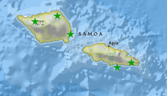
Samoa seismic network, FSDN code : WS
This network is managed and operated by the Geohazards section under the Samoa Meteorological Division:
- AFULI, Afulilo
- TOGIT, Togitogiga
- ASAU, Asau
- VAIAA, Vaiaata
- LEPIU, Lepiu
National institutions
National observatories & agencies responsible for hazards monitoring and alert dissemination:
Samoa Meteorological Division – SMD
Samoa National Seismic Network operates on a 24/basis and all members in the Geoscience Section play an important role in the National Data Centre (NDC) Operations. They are called to assist whoever is on duty when there is an Event that needsimmediate assistance/attention
| Mr. Lameko Talia | SMD Director | |
| Ms. Katie Pogi | Seismologist, SMD | |
| Mr. Faatali Maleafatu Leavasa | Seismologist, SMD |