 Independent State of Papua New Guinea
Geographical situation and geophysical context
Papua New Guinea is located on the eastern half of the island of New Guinea, as well as numerous smaller islands in the southwestern Pacific Ocean. Similar to the Solomon Islands, Papua New Guinea is situated within the Pacific Ring of Fire and exhibits a complex geophysical context. Here are some key aspects of the geophysical context of Papua New Guinea:
- Tectonic Setting: Papua New Guinea lies at the boundary of several tectonic plates, including the Pacific Plate, Australian Plate, and the Philippine Sea Plate. The interaction between these plates has resulted in the formation of a complex tectonic setting. Papua New Guinea is situated along a convergent plate boundary, where the Australian Plate is colliding with and subducting beneath the Pacific Plate. This collision has given rise to the New Guinea Trench, a deep oceanic trench to the north of the country.
- Earthquakes: The collision and subduction of tectonic plates in Papua New Guinea make it highly prone to seismic activity. The country experiences frequent earthquakes, ranging from small tremors to major events. The high seismicity is attributed to the convergence and interactions of the tectonic plates in the region.
- Volcanic Activity: Papua New Guinea is home to a significant number of active volcanoes. The most prominent volcanic areas are found in the eastern part of the country, including the Bismarck Volcanic Arc and the volcanoes of the New Britain and Bougainville Islands. Eruptions occur periodically, posing potential risks to nearby communities, including ashfall, lava flows, and lahars.
- Mountainous Terrain: The geology of Papua New Guinea is characterized by rugged and mountainous terrain. The Central Highlands run through the island of New Guinea, forming a backbone of steep mountains and deep valleys. These mountains are a result of tectonic forces, including uplift and folding, as well as erosion over millions of years.
- Geothermal Energy: Papua New Guinea has significant geothermal energy potential due to its geologically active nature. Hot springs and geothermal systems are found in various regions, particularly in the highlands. These geothermal resources offer opportunities for renewable energy development.
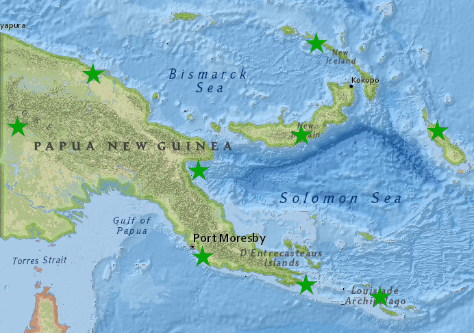
PNG seismic network, FSDN code : NG
- ALOT (Alotau), located in Milne bay.
- BUKA (Buka), located in Bougainville island.
- HAGN (Mount Hagen), located in Western Highlands.
- KAVG (Kavieng), located in New Ireland island.
- KIMB (Buluma Kimbe), located in West New Britain.
- LAE (Lae), located in Morobe province.
- MISM (Misima), located in Milne bay.
- TABU (Tabubil), located in the Star Mountains.
- TBLT (Renbo), located in Port Moresby.
- WEWK (Krier Heights), located in Wewak, Oriental Sepik province.
National institutions
National observatories & agencies responsible for hazards monitoring and alert dissemination:
PNG DEPARTMENT OF MINERAL POLICY & GEOHAZARDS MANAGEMENT – PMGO / RVO
| Raymond Yamai | DMPGM Director | |
| Ima Itikarai | DMPGM Assistant Director | |
| Felix Taranu | Principal seismologist, PMGO | |
| Mathew Moihoi | Seismologist, PMGO | |
| Deslone Lanbong | Seismologist, PMGO | |
| Mikhail Herry | Seismologist, RVO |